
Trails
- Home
- Trails
Kaçkar by UTMB
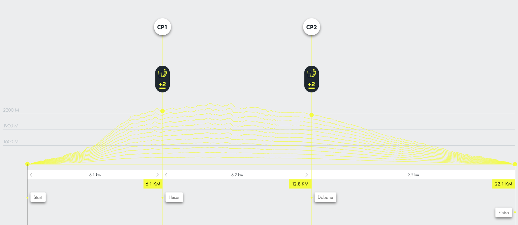
KAÇKAR 20K
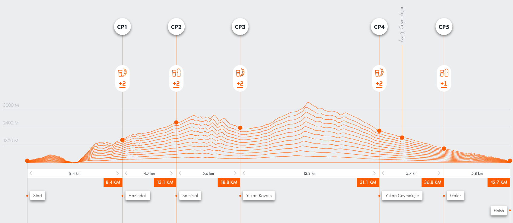
KAÇKAR 50K
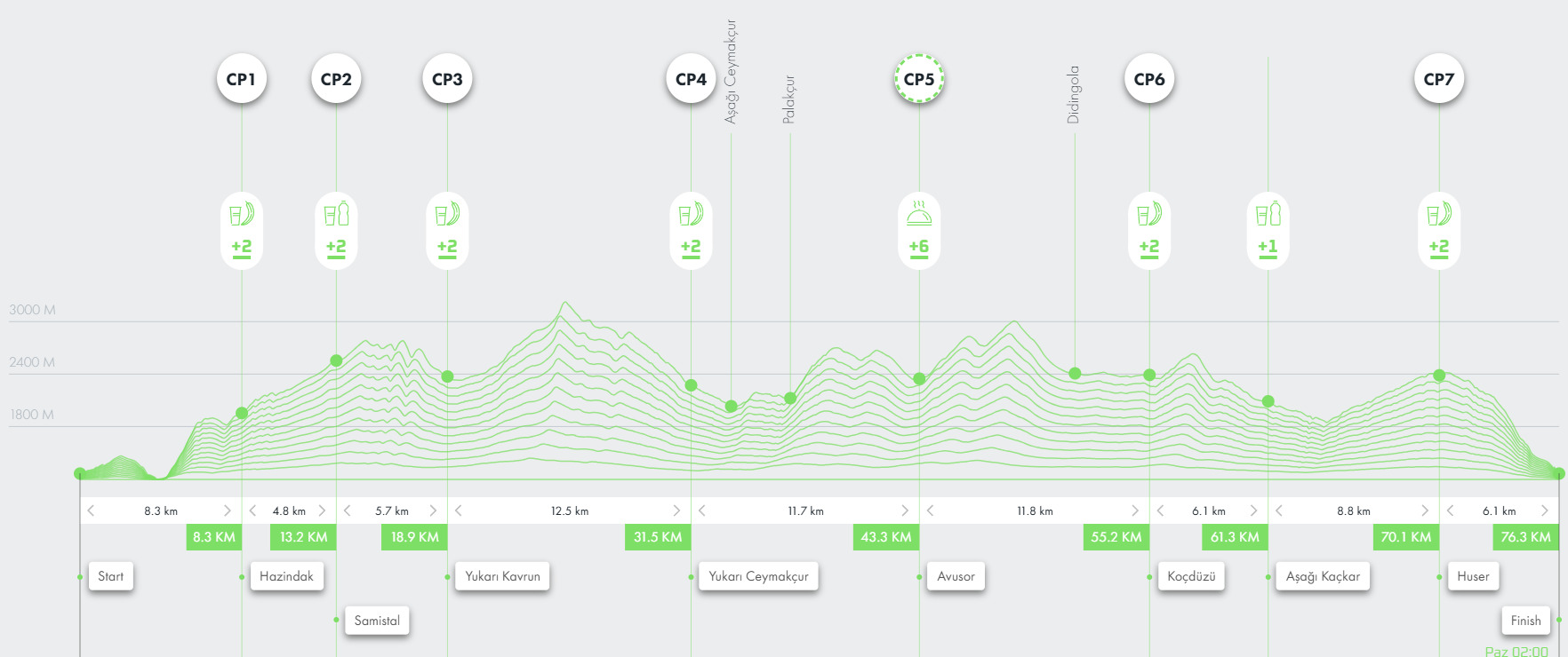
KAÇKAR 100K
Would you like us to arrange a discovery trip along the race trails? Get in touch with us today!
Trekking Routes Along the UTMB Trails
Didingola Plateau-Lelvan Lake-Didingola Plateau (round trip 7 km)
(Çamlıhemşin / Difficulty Level: 3)
Suitable for everyone. As you ascend, capturing beautiful photographic frames including Didingola Plateau and the valley you are in becomes possible.
Didingola Plateau-Kaçkar Lake-Dadala Lodge-Avusör Plateau (8.5 km)
(Çamlıhemşin / Difficulty Level: 3)
This route, most preferred by travel agencies, houses three lodges along the way. Throughout the journey, you will cross two passes of three thousand meters. Enjoy using your camera frequently while walking amidst the panoramic view of Altıparmak peaks.
Didingola Plateau-Neknar Lake-Didingola Plateau (round trip 4 km)
(Çamlıhemşin / Difficulty Level: 2)
An easy walk for everyone. The path to the southwest of the plateau is quite distinct. Following the stream coming from the same direction will guide you to the lake.
Koçdüzü Plateau-Kaçkar Plateau-Huser Plateau (14 km)
(Çamlıhemşin / Difficulty Level: 3)
The trail follows the old path up to Kaçkar Plateau and then reaches Huser Plateau via a dirt road.
Avusor Plateau-Ambar Lake-Dadala Pension (10 km)
(Çamlıhemşin / Difficulty Level: 4)
Participants in the hiking activity must cross two passes at an altitude of three thousand meters. Upon descending to the valley where Ambar Lake is located, you will notice that the trail is not very distinct. After the pass, the route traverses rocky terrain at times, leading down to the lakeshore. You can take a swimming break in the largest lake of the Kaçkar range. It’s advisable to plan this activity with camping. Enthusiastic hikers can choose to stay at Dadala Pension, which they pass by midway.
Avusor Plateau-Büyük Lake-Avusor Plateau (round trip 4 km)
(Çamlıhemşin / Difficulty Level: 2)
This day trip, suitable for everyone, is one of the walking routes around Ayder Plateau. The lake is situated to the south of the plateau. Starting from the pension at Avusor Plateau, you can walk to Büyük Lake.
Avusor Plateau-Kaçkar Plateau (9 km)
(Çamlıhemşin / Difficulty Level: 3)
This picturesque trail offers views of the valleys of Avusor and Kaçkar rivers simultaneously. The first part involves ascent, while the latter part follows a descent after the pass.
Avusor Plateau-Peryatak-Çamyatak-Huser Plateau (9 km)
(Çamlıhemşin / Difficulty Level: 3)
One of the most frequented walking routes in Rize. A significant advantage of this trail is its proximity to Ayder Plateau. Starting from the plateau, the path progresses northwest, reaching Huser.
Huser Plateau-Ayder Plateau (3.5 km)
(Çamlıhemşin / Difficulty Level: 1)
You may encounter various mushroom species along this easily walkable route. Huser Plateau, located at the starting point of this trail near Ayder, also serves as a natural observation terrace where you can capture the entire Kaçkar mountain range in photos.
Hazindak Plateau-Pokut Plateau (7 km)
(Çamlıhemşin / Difficulty Level: 1)
A scenic ridge walk overlooking Ayder and Palovit valleys. The final part of the route is an old path, while the rest is a newly constructed dirt road.
Yukarı Çaymakçur Plateau-Karadeniz Lake-Naletleme Pass-Döbedüzü-Olgunlar (11 km)
(Çamlıhemşin-Yusufeli / Difficulty Level: 5)
A route that’s one of the paths for climbing the Kaçkar summit, crossing the 3200-meter Naletleme pass. Along the trail following a distinct path, you might encounter other hikers. The initial section is a continuous ascent up to Naletleme Pass. After crossing Karadeniz Lake, you start ascending amidst small lakes. Following the pass, you’ll descend towards Döbedüzü. From there, heading east, you’ll relatively walk on a flat path towards Olgunlar.
Yukarı Çaymakçur Plateau-Karadeniz Lake-Unnamed Lake-Yukarı Kavron Plateau (7 km)
(Çamlıhemşin / Difficulty Level: 3)
One of the day hike trails near Ayder Plateau. Along this route, you have the chance to see three glacial lakes. Starting from Yukarı Çaymakçur, the route ascends southward towards the lakes. From this point, you can descend eastward. Aşağı Kavron Plateau-Galer Düzü-Ayder Plateau (10 km) (Çamlıhemşin / Difficulty Level: 1)
This day trip near Ayder Plateau is easily walkable for everyone. The initial part is a trail, while the latter part is a dirt road.
Yukarı Kavron Plateau-Unnamed Lake-Karadeniz Lake-Naletleme Pass-Döbedüzü-Olgunlar (11 km)(Çamlıhemşin-Yusufeli / Difficulty Level: 5)
This route is a combination of routes 33 and 34, starting from Yukarı Kavron Plateau and leading to the Unnamed Lake. Shortly after, it descends to Karadeniz Lake and then follows the same path as route 33.
Yukarı Kavron Plateau-Derebaşı Lake-Yukarı Kavron Plateau (round trip 10 km)
(Çamlıhemşin / Difficulty Level: 3)
By following the streambed from the south towards Yukarı Kavron Plateau, you can easily reach the lake. The return will follow the same route.
Yukarı Kavron Plateau-Öküzyatağı Lake-Mezovit Lake-Büyükdeniz Lake-Unnamed Lake-Yukarı Kavron Plateau (12 km)
(Çamlıhemşin / Difficulty Level: 5)
This considerably long and exhausting route rewards hikers with encounters of five glacial lakes along the way. You can plan this route for camping. Initially, the path proceeds southward, then turns eastward towards Öküzyatağı. From Mezovit Lake, heading north towards Büyükdeniz Lake, then westward leads you back to the starting point.
Yukarı Kavron Plateau-Derebaşı Lake-Kavron Pass-Apivanak Plateau (9 km)
(Çamlıhemşin / Difficulty Level: 4)
This trail, crossing the 3300-meter-high Kavron Pass via a very distinct path, leads to Apivanak Plateau. The route involves a gentle ascent up to the location of Derebaşı Lake, followed by swiftly rising switchbacks through a path towards Kavron Pass. The subsequent section of the route descends to Apivanak Plateau.
Hazindak Plateau-Amlakit Plateau (4 km)
(Çamlıhemşin / Difficulty Level: 2)
Relatively easy, this walking route progresses towards Amlakit Plateau, moving southward through a partly stone-paved, distinct path.
Hazindak Plateau-Samistal Plateau (5 km)
(Çamlıhemşin / Difficulty Level: 2)
Mostly identical to the previous route, this path, near Amlakit, turns eastward, reaching Samistal through an old pasture path.
Samistal Plateau-Yukarı Kavron Plateau (6.5 km)
(Çamlıhemşin / Difficulty Level: 3)
Starting from Samistal, a traditional plateau in Rize, this route descends to Yukarı Kavron after crossing the pass near Kavron Peak. Note that the path might be obscured in places due to landslides after the pass, so caution is advised.
Samistal Plateau-Aşağı Kavron Plateau (6 km)
(Çamlıhemşin / Difficulty Level: 2)
Following the same path as route 43 until the pass, this route then heads north towards Aşağı Kavron Plateau.